Want more images or videos?
Request additional images or videos from the seller.

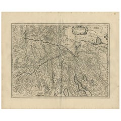
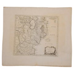
Antique Map of the Region of Aargau by Janssonius, '1657'

$677.01
£511.62
€600VAT Included
CA$965.25
A$995.10
CHF 565.41
MX$12,596.12
NOK 6,474.70
SEK 6,783.05
DKK 4,575.07

About the Item

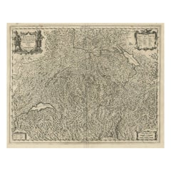
Antique map 'Argow cum parte merid. Zurichgow'. Detailed map of Switzerland showing Aargau with the southern part of Zürich. This map originates from 'Atlas Novus, Sive Theatrum Orbis Orbis Terrarum: In quo Galliae, Helvetiae (..)' by J. Janssonius (1656-1657).
  • Creator:
  • Dimensions:
    Height: 14.97 in (38 cm)Width: 19.69 in (50 cm)Depth: 0.02 in (0.5 mm)
  • Materials and Techniques:
  • Period:
    Mid-17th Century
  • Date of Manufacture:
    1657
  • Condition:
    Wear consistent with age and use. General age-related toning. Minor foxing. Latin text on verso. Please study images carefully.
  • Seller Location:
    Langweer, NL
  • Reference Number:
    Seller: BG-12082-611stDibs: LU3054316482471

More From This Seller

View All
Antique Map of Northern Switzerland by Janssonius '1657'

Antique Map of Northern Switzerland by Janssonius '1657'

By Johannes Janssonius

Located in Langweer, NL

Antique map 'Zurichgow et Basiliensis provincia'. Detailed map of northern Switzerland, including Zurich and Basel. This map originates from 'Atlas Novus, Sive Theatrum Orbis Orbis T...

Category

Antique Mid-17th Century Maps

Materials

Paper

Antique Map of the Region of Lake Geneva by Janssonius '1657'

Antique Map of the Region of Lake Geneva by Janssonius '1657'

By Johannes Janssonius

Located in Langweer, NL

Antique map 'Das Wiflispur Gergow'. Detailed map of Switzerland showing Waadt and the Lake of Geneva and the city of Geneva, Fribourg and partly Bern. This map originates from 'Atlas...

Category

Antique Mid-17th Century Maps

Materials

Paper

Antique Map of Austria by N. Visscher, circa 1690

Antique Map of Austria by N. Visscher, circa 1690

Located in Langweer, NL

Antique map titled 'Austriae Archiducatus pars superior in omnes ejusdem'. Spectacular large map of Upper and Lower Austria between Passau and Wien with figurative cartouche and armo...

Category

Antique Late 17th Century Maps

Materials

Paper

Antique Map of the Region of Nivernais by Janssonius, 1657

Antique Map of the Region of Nivernais by Janssonius, 1657

By Johannes Janssonius

Located in Langweer, NL

Antique map of France titled 'Carte du Païs et Duché de Nivernois'. Decorative map of the Nivernais region, part of Burgundy, France. This map originates from 'Atlas Novus, Sive Thea...

Category

Antique 17th Century Maps

Materials

Paper

Decorative and Detailed Original Antique Map of Switzerland, 1657

Decorative and Detailed Original Antique Map of Switzerland, 1657

Located in Langweer, NL

Antique map of Switzerland titled 'Helvetiae Rhetiae & Valesiae'. Decorative and detailed map of Switzerland. This map originates from 'Atlas Novus, Sive Theatrum Orbis Orbis Ter...

Category

Antique 1650s Maps

Materials

Paper

You May Also Like

1657 Janssonius Map of Vermandois and Cappelle, Ric. A-004

1657 Janssonius Map of Vermandois and Cappelle, Ric. A-004

Located in Norton, MA

1657 Janssonius map of Vermandois and Cappelle Ric.a004 Description: Antique map of France titled 'Descriptio Veromanduorum - Gouvernement de la Cappelle'. Two detailed maps o...

Category

Antique 17th Century Unknown Maps

Materials

Paper

1640 Joan Bleau Map Entitled"Diocecese de rheims et le pais de rethel, Eic.a011

1640 Joan Bleau Map Entitled"Diocecese de rheims et le pais de rethel, Eic.a011

Located in Norton, MA

1640 Joan Bleau map entitled "Diocecese de rheims et le pais de rethel," Ric.a011 OAN BLAEU Diocecese de Rheims, et le pais de Rethel. Handcolored engraving, c.1640. ...

Category

Antique 17th Century Dutch Maps

Materials

Paper

17th Century Hand Colored Map of the Liege Region in Belgium by Visscher

17th Century Hand Colored Map of the Liege Region in Belgium by Visscher

By Nicolaes Visscher II

Located in Alamo, CA

An original 17th century map entitled "Leodiensis Episcopatus in omnes Subjacentes Provincias distincté divisusVisscher, Leodiensis Episcopatus" by Nicolaes Visscher II, published in Amsterdam in 1688. The map is centered on Liege, Belgium, includes the area between Antwerp, Turnhout, Roermond, Cologne, Trier and Dinant. This attractive map is presented in a cream-colored mat measuring 30" wide x 27.5" high. There is a central fold, as issued. There is minimal spotting in the upper margin and a tiny spot in the right lower margin, which are under the mat. The map is otherwise in excellent condition. The Visscher family were one of the great cartographic families of the 17th century. Begun by Claes Jansz Visscher...

Category

Antique Late 17th Century Dutch Maps
Materials

Paper

1627 Hendrik Hondius Map Entitled "Vltoniae Orientalis Pars, " Ric.a009

1627 Hendrik Hondius Map Entitled "Vltoniae Orientalis Pars, " Ric.a009

Located in Norton, MA

1627 Hendrik Hondius map entitled "Vltoniae orientalis pars," Ric.a009 Title: Vltoniae orientalis : pars Title (alt.) : Ultoniae orientalis pars Creator: Mercator, Gerh...

Category

Antique 17th Century Dutch Maps
Materials

Paper

18th-century Antique Map of Austria and Slovenia

18th-century Antique Map of Austria and Slovenia

By Christoph Weigel

Located in Wilton Manors, FL

Christoph Weigel (1654-1725) Map of Austria and Slovenia, 1719. Hand-colored engraving on laid paper. Plate measures 15.25 x 12.75 inches. Framed measurement: 19 x 21 inches. Jo...

Category

1710s Landscape Prints

Materials

Engraving